National
Assam floods; Life is not all right there
By Komal Akanksha.
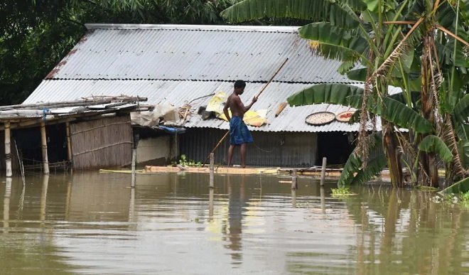
Floods have become a common sight in the North eastern regions of our country. The problem of severe floods is faced every year particularly in Bihar and Assam, due to perennial river systems. This year as the situation was different due to lockdown since the month of march, the monsoon rates are more than average and rivers are flowing at above danger levels. The Brahmaputra and Barak River with more than 50 numbers of tributaries feeding them, cause the flood devastation in the monsoon period each year.
In Assam the worst hit districts are Goalpara (the worst hit district), Barpeta, Morigaon, Dhubri and South Salmara. Over 57 lakhs of people have been affected in Assam with death toll amounting to 87. In Assam not only people but animals of Kaziranga National Park and Tiger Reserve (KNTPR) with 85 percent of KNTPR, so far, 125 animals have been rescued and 86 have died, including rhinos, deer and wild boar, in the sixth worst flood since 1988.
त्रिपुरा के मुख्यमंत्री ने जाटों, पंजाब के लोगों के साथ बंगाल के लोगों की तुलना करने पर मांगी माफी
Assam is traditionally flood prone and 1055 sq km KNTPR sandwiched between Brahmaputra river and the Karbi Anglong hills being a flood plain area is a solid landmass ecosystem. According to Uttam Saikia, Honorary Wildlife Warden of Kaziranga, this “floodplain ecosystem” has not only been created by floods but also feeds off it. Saikia said the floodwaters also function as a breeding ground for fish. “The same fish are carried away by the receding waters into the Brahmaputra — in a way, the park replenishes the river’s stock of fish too,” he said. Many also believe that floods are a way of natural selection. “A number of animals — especially the old, weak — cannot survive the floods. Only the ones with superior genes survive,” said Rabindra Sarma, Wildlife Research Officer at KNPTR since 1998.
Apart from incessant rainfall during the monsoon, there are many contributory factors, natural and man-made. At the crux is the very nature of the river Brahmaputra —dynamic and unstable. Its 580,000 sq km basin spreads over four countries: China, India, Bangladesh and Bhutan, with diverse environments. Assam being earthquake prone region the Brahmaputra has not been able to acquire a stable character besides these natural factors manmade factors – habitation, deforestation, population growth in catchment areas that lead to higher sedimentation.
CM of the state Sarbananda Sonowal visited the erosion-hit areas of Tulsijhara in Chirang district and flood-affected areas of Jamdaha (Bekar Chowk Bazar) in Bongaigaon district and assessed the devastation caused by the river Aie. He also visited flood relief camps set up at Majharabari LP School and Nowapara LP School by the Chirang district administration and took stock of the government services being provided at the camps.
There has been excess emphasis for investing in structural solutions like building of embankments and little focus on natural flood control mechanisms based on local topography. Till date, close to 5,000 km of embankments have been built at various points along the Brahmaputra and its tributaries. This has resulted in restricting the flow of river during peak monsoons and caused increased pressure on embankments in vulnerable areas leading to embankments being breached at several places.
It is time for the government and related agencies to review the existing policy of building embankments without considering natural outlets for excess water to flow. This will work best when local people are made stakeholders in finding localized solutions based on local topography.